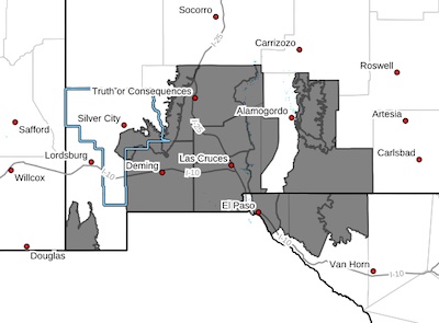
 Southern Gila Foothills/Mimbres Valley-Uplands of the Bootheel-
Southwest Desert/Mimbres Basin-Eastern Black Range Foothills-
Sierra County Lakes-Northern Dona Ana County-Southern Dona Ana
County/Mesilla Valley-West Slopes Sacramento Mountains Below
7500 Feet-Sacramento Mountains Above 7500 Feet-East Slopes
Sacramento Mountains Below 7500 Feet-Otero Mesa-West Central Tularosa Basin/White Sands-
Eastern/Central El Paso County-
Northern Hudspeth Highlands/Hueco Mountains-Salt Basin-
Including the cities of Columbus, Spaceport, Mayhill, Winston,
Hatch, Faywood, Hueco Tanks, Loma Linda, Hurley, Sunspot,
Socorro, Las Cruces, Garfield, Mountain Park, East and Northeast
El Paso, Derry, Dell City, Cloudcroft, Sacramento, Crow Flats,
Pinon, Radium Springs, Fort Bliss, Hillsboro, Grant County
Airport, White Sands Range Headquarters, Vado, Chaparral,
Mescalero, Cloverdale, Timberon, Deming, White Sands National
Park, Salt Flat, Cornudas, Sunland Park, Apache Summit, and Truth
Or Consequences
1226 PM MDT Sat Apr 13 2024
...HIGH WIND WARNING IN EFFECT FROM 1 PM TO 10 PM MDT MONDAY...
* WHAT...West winds 35 to 45 mph with gusts up to 60 mph expected in
the lowlands and up to 70 MPH in higher elevations and east slope
areas.
* WHERE...Portions of south central and southwest New Mexico and
southwest Texas.
* WHEN...From 1 PM to 10 PM MDT Monday.
* IMPACTS...Damaging winds will blow down trees and power lines.
Widespread power outages are expected. Travel will be difficult,
especially for high profile vehicles.
PRECAUTIONARY/PREPAREDNESS ACTIONS...
Remain in the lower levels of your home during the windstorm, and
avoid windows. Watch for falling debris and tree limbs. Use caution
if you must drive.