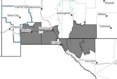
 Southwest Desert/Mimbres Basin-Southern Dona Ana County/Mesilla
Valley-Otero Mesa-Eastern/Central El Paso County-Northern
Hudspeth Highlands/Hueco Mountains-Salt Basin-
Including the cities of Dell City, Deming, Sunland Park,
Columbus, Las Cruces, Socorro, Fort Bliss, Loma Linda, East and Northeast El Paso, Hueco Tanks, Salt Flat, Cornudas, Vado, and Crow Flats
Mon Apr 15 2024
...BLOWING DUST ADVISORY IN EFFECT UNTIL 5 PM MDT THIS AFTERNOON...
...HIGH WIND WARNING REMAINS IN EFFECT UNTIL 10 PM MDT THIS
EVENING...
* WHAT...For the Blowing Dust Advisory, visibility between one-half
and two miles in blowing dust. For the High Wind Warning, west
winds 30 to 40 mph with gusts up to 55 mph expected.
* WHERE...In New Mexico, Otero Mesa, Southern Dona Ana
County/Mesilla Valley, and Southwest Desert/Mimbres Basin. In
Texas, Eastern/Central El Paso County, Northern Hudspeth
Highlands/Hueco Mountains, and Salt Basin.
* WHEN...For the Blowing Dust Advisory, until 5 PM MDT this
afternoon. For the High Wind Warning, until 10 PM MDT this evening.
* IMPACTS...Hazardous driving conditions due to reduced visibility.
Damaging winds will blow down trees and power lines. Power outages
are expected. Travel will be difficult, especially for high
profile vehicles.
PRECAUTIONARY/PREPAREDNESS ACTIONS...
Persons with respiratory problems should make preparations to stay
indoors until the storm passes. Be ready for a sudden drop in
visibility to near zero. If you encounter blowing dust or blowing
sand on the roadway or see it approaching, pull off the road as far
as possible and put your vehicle in park. Turn the lights all the
way off and keep foot off the brake pedal. Remember, 'Pull Aside,
Stay Alive'.
Remain in the lower levels of your home during the windstorm, and
avoid windows. Watch for falling debris and tree limbs. Use caution
if you must drive.