


EXTENDED Heat Advisory in effect through 6 am MDT Tuesday 071123
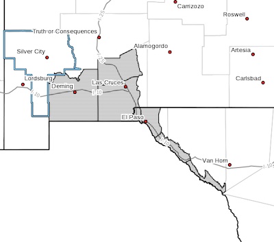 Southwest Desert/Mimbres Basin-Northern Dona Ana County-
Southern Dona Ana County/Mesilla Valley-Western El Paso County-
Eastern/Central El Paso County-
Rio Grande Valley of Eastern El Paso/Western Hudspeth Counties-
Rio Grande Valley of Eastern Hudspeth County-
Including the cities of Deming, Columbus, Garfield, Hatch,
Radium Springs, Las Cruces, Vado, Sunland Park, Downtown El Paso,
West El Paso, Upper Valley, East and Northeast El Paso, Socorro,
Fort Bliss, Fabens, Fort Hancock, Tornillo,
and Indian Hot Springs
1255 PM MDT Wed Jul 5 2023
Pass Fire Update July 5, 2023
- Category: Front Page News Front Page News
- Published: 05 July 2023 05 July 2023
Pass Fire
Gila National Forest Incident Commander Robert Laeng IC and Josh Johnson IC(T)
Hours: 8 am-4:30 pm Email: 2023.Pass@Firenet.gov
Acres: 59,904
Location: 40 miles west of Winston, NM
Containment: 32%
Personnel: 140, 1 Type 3 Helicopter
Start Date: May 18, 2023
Cause: Lightning
Fuels: Timber, piñon/juniper and grass
Containment on the Pass Fire has increased as fire crews accomplished work to secure containment lines along the southeastern edge of the perimeter resulting in the protection of private inholdings adjacent to the Gila National Forest. Hand ignitions performed the last couple of days allowed the fire to burn out excess vegetation along Iron Trail #771 and White Rocks Trail #27, with the goal of improving and securing containment lines. Today, firefighters will monitor and patrol the Pass Fire by ground and air to ensure those containment lines stay secured. Containment lines act as boundaries to keep the fire corralled until it is completely out.
Pass Fire Update July 4, 2023
- Category: Front Page News Front Page News
- Published: 04 July 2023 04 July 2023
Pass Fire
Gila National Forest Incident Commander- Robert Laeng IC and Josh Johnson IC(T)
Hours: 8 am-4:30 pm
Email: 2023.Pass@Firenet.gov
Acres: 59,889
Location: 40 miles west of Winston, NM
Containment: 12%
Personnel: 140, 1 Type 1 Helicopter, 1 Type 3 Helicopter
Start Date: May 18, 2023
Cause: Lightning
Fuels: Timber, piñon/juniper and grass
Yesterday, favorable conditions allowed firefighters to successfully complete hand ignition operations on the southeastern part of the fire perimeter where the Pass Fire is most active, along Iron Trail #771. This resulted partly in a 500-acre growth and a more secure established containment line consisting of Iron Trail #771 and White Rocks Trail #27. Fire crews burned out excess vegetation to create a buffer that would slow or stop the Pass fire and future fires from impacting adjacent private property and other values at risk. Today, fire crews will patrol and monitor the newly established containment line along the southeastern edge, extinguishing any fire to hold and secure it. Interior light smoke has also been visible on the west side of the Pass Fire near No Name Canyon and is being closely monitored.
Pass Fire Update July 3, 2023
- Category: Front Page News Front Page News
- Published: 03 July 2023 03 July 2023
Pass Fire
Gila National Forest Incident Commander Robert Laeng IC
Information Phone: 575-388-8211 Hours: 8 am-4:30 pm
Email: Maribeth.Pecotte@usda.gov
Acres: 59,367
Location: 40 miles west of Winston, NM Containment: 12%
Personnel: 140, 1 Type 1 Helicopter, 2 Type 3 Helicopters
Start Date: May 18, 2023
Cause: Lightning
Fuels: Timber, piñon/juniper and grass
Yesterday, crews successfully conducted hand ignitions along the Iron Trail #771. If conditions prove favorable today, they will continue to use hand ignitions off of Iron Trail #771 to increase containment around the southeast corner of the fire perimeter to provide protection to private property nearby. Firefighters are monitoring the whole fire area daily from air and ground. Increase or decrease in acreage is due more to accurate mapping.
Dust Advisory 070323
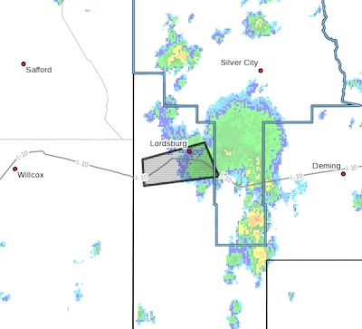 The National Weather Service in El Paso has issued a
* Dust Advisory for...
Southern Grant County in southwestern New Mexico...
West central Hidalgo County in southwestern New Mexico...
* Until 445 PM MDT.
* At 340 PM MDT, an area of blowing dust was visible on highway
cameras east of Lordsburg. With storms nearby, this area could
easily see visibility drop quickly due to outflow boundaries.
Flood advisory 070323
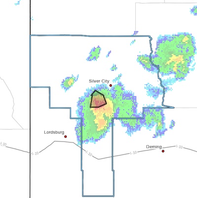 FLOOD ADVISORY IN EFFECT UNTIL 430 PM MDT THIS AFTERNOON...
* WHAT...Flooding caused by excessive rainfall is expected.
* WHERE...A portion of southwest New Mexico, including the following
county, Grant.
* WHEN...Until 430 PM MDT.
* IMPACTS...Minor flooding in low-lying and poor drainage areas.