


The Chronicles of Grant County
This column will feature items that relate somehow to Grant County - the name of a street in the case of the first one, and maybe other streets, or the name of a building or whatever catches the fancy of the contributor, Richard Donough. Readers are encouraged to send him topics of interest to them, so he can do the research and write an article.
Bureau Of Land Management Photo Contest For 2024
- Category: The Chronicles of Grant County The Chronicles of Grant County
- Published: 09 August 2023 09 August 2023
The Chronicles Of Grant County
Bureau Of Land Management
Photo Contest For 2024
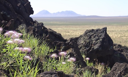
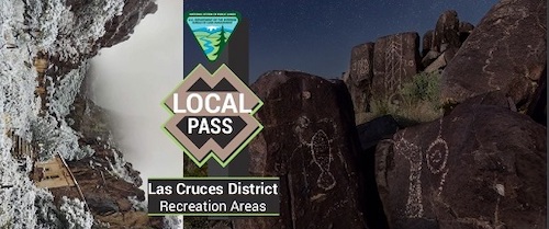 Displayed here is the front of the 2023 Local Pass for access to the recreation areas of the Las Cruces District of the Bureau of Land Management (BLM). The pass includes photos produced by the two people who won the "Picture That Pass Photo Contest" of the local district of the BLM in 2023. According to the BLM, the photo of the Three Rivers Petroglyphs (to the right) was produced by David Turning, while the Dripping Springs Snowfall photo (to the left) was produced by John Ferrales. (The photograph was provided courtesy of the Bureau of Land Management, July 26, 2023.)
The Las Cruces District of the Bureau of Land Management (BLM) is conducting a photo contest again this year. Entries are now being accepted for the "Picture That Pass Photo Contest" of the local district of the BLM in 2024.
The district of this Federal agency includes all of public lands managed by the BLM in Grant County as well as a number of other counties in southwestern New Mexico. Substantial portions of Grant County as well as southern New Mexico are controlled by the BLM.
Bureau Of Land Management Recreation Areas Fee-Free Day On August 4, 2023
- Category: The Chronicles of Grant County The Chronicles of Grant County
- Published: 02 August 2023 02 August 2023
The Chronicles Of Grant County
Bureau Of Land Management Recreation Areas
Fee-Free Day On August 4, 2023
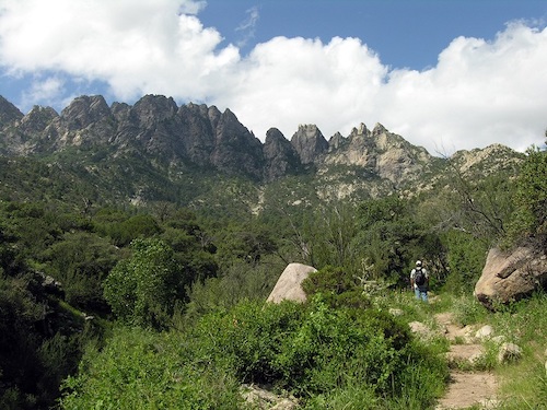 The Aguirre Spring Recreation Area is one of the recreation areas of the Las Cruces District of the Bureau of Land Management (BLM) that will waive entrance fees for visitors on Friday, August 4, 2023. (The photograph was provided courtesy of the Bureau of Land Management, August 24, 2008.)
Are you looking for something to do on Friday? Perhaps start your weekend a day earlier?
If so, you may want to consider visiting one of three major recreation sites controlled by the Bureau of Land Management (BLM).
The Las Cruces District of the BLM recently announced that folks will be able to visit its recreation sites in southern New Mexico on Friday, August 4, without paying entrance fees.
This waiver of entrance fees is being done as part of BLM's participation in the Great American Outdoors Day.
Arizona Street Hurley
- Category: The Chronicles of Grant County The Chronicles of Grant County
- Published: 26 July 2023 26 July 2023
The Chronicles Of Grant County
Arizona Street
Hurley
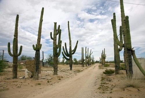 A view of saguaro cacti in a rural area of Arizona near the Town of Florence. (The photograph was produced by Carol Highsmith and provided courtesy of the Library of Congress, August 25, 2008.)
Arizona Street is a roadway in the Town of Hurley in Grant County. The street was named after Arizona. Several other area communities have roads with this name.
"Arizona, formerly part of the Territory of New Mexico, was organized as a separate territory on February 24, 1863," according to a statement from the Library of Congress. "The United States acquired the region under the terms of the 1848 Treaty of Guadalupe Hidalgo and the 1853 Gadsden Purchase." Both the treaty and the purchase were made with Mexico.
Juniper Avenue – Reserve and Juniper Street – Silver City
- Category: The Chronicles of Grant County The Chronicles of Grant County
- Published: 19 July 2023 19 July 2023
The Chronicles Of Grant County
Juniper Avenue – Reserve
Juniper Street – Silver City
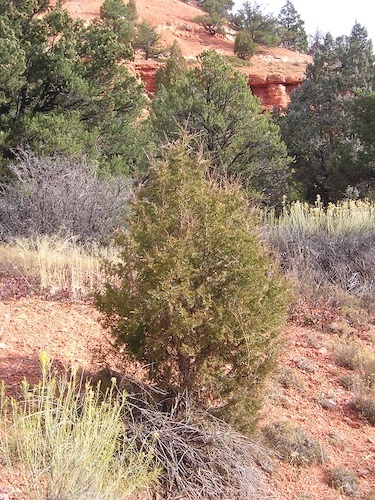 A Juniper Tree in the Dixie National Forest in Cedar City, Utah. (The photograph was provided courtesy of the United States Forest Service.)
Juniper Street in Silver City, Grant County, and Juniper Avenue in Reserve, Catron County, get their names from the Juniper tree.
"The Juniper tree is typically found in areas that have an elevation between 3,000 and 8,000 feet," according to a statement issued by the United States Forest Service (FS) of the U S Department of Agriculture (USDA). "This tree grows among the pinyon pine trees and sagebrush. The short scale-like needles are one-eighth inch long and last several years. Foliage and branches are stiff. Seeds are borne in berry-like scaled cones. The cones, when mature, are up to a half-inch in diameter and bronze in color with a bluish-white frosting."
Organ Mountains-Desert Peaks National Monument Public Planning Meetings
- Category: The Chronicles of Grant County The Chronicles of Grant County
- Published: 10 July 2023 10 July 2023
The Chronicles Of Grant County
Organ Mountains-Desert Peaks National Monument
Public Planning Meetings
 A view of the Mount Riley Wilderness Area from the Aden Lava Flow Wilderness Study Area of the Organ Mountains-Desert Peaks National Monument. (The photograph was provided courtesy of the United States Bureau of Land Management, May 22, 2014.)
The public is invited to attend a meeting tomorrow – Tuesday, July 11 – in Deming to review and provide comments on the Resource Management Plan (RMP) for the Organ Mountains-Desert Peaks National Monument.
The meeting is being held by the United States Bureau of Land Management (BLM) from 6 PM to 8 PM at the Mimbres Valley Special Events Center, 2300 East Pine Street in Deming.
The Organ Mountains-Desert Peaks National Monument is managed by the BLM and includes 496,529 acres of land in Doña Ana County.
Freedom Trail Pinos Altos
- Category: The Chronicles of Grant County The Chronicles of Grant County
- Published: 02 July 2023 02 July 2023
The Chronicles Of Grant County
Freedom Trail
Pinos Altos
 (The image was provided courtesy of Angelique Johnson through Pixabay.)
Freedom Trail in Pinos Altos received its name from the freedom – the liberty that people in the United States were accorded through the U S Constitution. According to a statement from The White House, “the First Amendment [of the Constitution] provides that Congress make no law respecting an establishment of religion or prohibiting its free exercise. It protects freedom of speech, the press, assembly, and the right to petition the Government for a redress of grievances.”
While Americans celebrate Independence Day on the Fourth of July, the actual Declaration of Independence took place two days earlier.
Bornite Street Tyrone
- Category: The Chronicles of Grant County The Chronicles of Grant County
- Published: 28 June 2023 28 June 2023
The Chronicles Of Grant County
Bornite Street
Tyrone
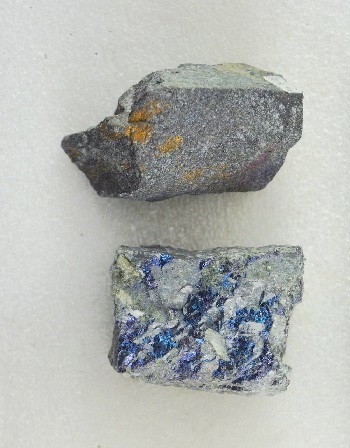 Bornite found at the Snowstorm Mine in the Ashcroft Mining District of British Columbia, Canada. (The photograph was provided courtesy of the Pacific Museum of Earth of The University of British Columbia, November 2, 1993.)
Bornite Street is one of the roadways in Tyrone that reflect the mining heritage of Grant County.
Bornite is a sulfide mineral – a copper ore mineral.
It has also been known as "peacock ore" because of its coloring that resembles the colors of the feathers of a peacock.
According to multiple reports, the mineral was discovered by a European in 1725. It went by several different names until 1845. In that year, it was given the name of "Bornite" by a second European. (The original sources for this information have not been located.)
Alamogordo Street in Deming
- Category: The Chronicles of Grant County The Chronicles of Grant County
- Published: 21 June 2023 21 June 2023
The Chronicles Of Grant County
Alamogordo Street
Deming
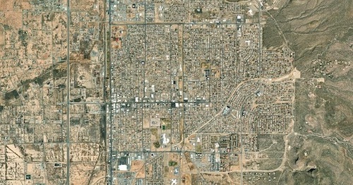 An aerial view of Alamogordo, New Mexico. (The photograph was provided courtesy of the United States Geological Survey, 2023.)
Alamogordo Street is a one-block long avenue in the City of Deming in Luna County. The street was named after Alamogordo, the county seat of Otero County, New Mexico.
A settlement was formally established by the El Paso and Northeastern Railroad at the site of today's Alamogordo in 1898. The name for this planned community was chosen by the railroad through the Alamogordo Improvement Company. "Alamogordo" is a combination of two Spanish words for "fat Poplar" or "fat Cottonwood" as in "Poplar tree" or "Cottonwood tree." Both "Poplar" and "Cottonwood" are used interchangeably by people in regards to the same tree.
Before the name was used for this community, "Alamogordo" was utilized as the name of a rail engine car by this railroad.